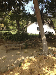
The garden around the Vallejo Adobe is often referred to as the "Reimers garden". So far, I found this out about Johannes Reimers. The original design for the garden still exists in the archives (supposedly).
Johannes Reimers could be considered (at least by me) a really early drought-tolerant garden planner. He planned gardens for some of the driest most neglected areas, railroad stations.
On August 25, 2013, I walked around the fence and took pictures from every direction. The fence around the Vallejo Adobe is generally locked, so this is the view I will give you now. I do have some photos that I will post later on, from a tour that I took in April or May.
I haven't identified any of the plants in these pictures yet, but you can look at the California Nursery Company Tree Inventory. And if you click on the photos, they will be bigger, so you can ID them yourself for now.
I measured the garden in my walk around the fence by pacing it out, so this is an estimate. The garden is roughly 105 foot square.
 |
| The blue square roughly follows the fence around the Old Adobe. North is at the top of the photo. I refer to northside of garden the as top of blue square, even though it's not quite exact. Go to my google map (which will be changing as I add stuff to it) |
 |
| From southwest corner, there is a gravel path and some trees and then you can see that there is a lawn around the adobe. (lower left corner of blue square on google map) |
 |
| South entrance, looking North, panorama (from southmost section on map) |
 |
| From southeast corner, panorama (from bottom right corner of map) |
 |
| You can see the buttresses added to adobe. (From southeast, walking toward northeast corner) |
 |
| From East side, looking at entrance to Old Adobe. (From middle of right side of blue square) |
 |
| From northeast corner, panorama (from top right corner of map) |
 |
| From the north side middle part of fence, looking at main entrance to Old Adobe. (from top of blue square, looking south) |
 |
| From northwest corner, panorama (from top left corner of map, looking southeast) |
 |
| Northwest side of adobe (walking from northwest corner of blue square, south) |
 |
| From the westside of fence (about mid-point of left side of blue square) |
 |
| From the West side, looking at end of Old Adobe. (Almost to the southwest corner of blue square) |

No comments:
Post a Comment